
Wikimedia Commons
At a recent meeting of the Royal Dublin Society Dr. W. Frazer exhibited a copy of Tassin’s maps of the fortified towns of France, which was additionally interesting by its containing several original plans drawn by Tassin and bird’s-eye views of Casal and Evreux. It also contained a manuscript map of the opposite coasts of France and Britain, apparantly of the most scrupulous accuracy, and a Chart ot the Islands and Maritime Coasts of Europe, in which is to be seen the route and navigation of the Hollanders by the north of Ireland and Scotland during the wars with the English for the German Ocean.
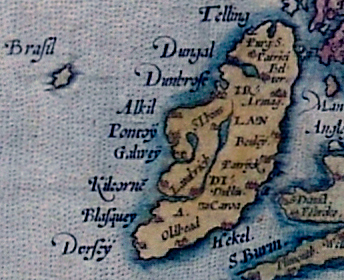
The course is laid down from Holland along the Norwegian coasts then passes between Fair Island and Foula. It then continues along the western coast of Ireland passing Brazil, which is laid down much in the position now ascertamed to be occupied by the Porcupine Bank and hence the course continues direct to Rochelle.
This map is evidently no fanciful sketch. Every sailing point and headland has been skilfully laid down, either by one who has passed over the track itself, or by one who compiled it from most competent authority, and this at a time when no British ships appear to have sailed over these western seas, though we know that the Dutch and French sailors almost daily did.
The probable date of the unpublished and apparently unique work is 1640. This copy appears to be in the very handwriting of Tassin himself, who was geographer to the King, and it would, indeed, appear most probable that Brazil did, as an island, at this or about this time, hold its head over the waters of the North Atlantic Ocean, though over its site, and after a lapse of more than two centuries, those very waters, to the depth of from 80 to 100 fathoms, now roll.
The evidence, then, would be in favour of Brazil having existed as an island off the entrance to Galway Bay in A.D. 1640, or thereabout, and of its having gradually subsided into the bosom of the ocean.
